About Friend, Nebraska
Friend is located in Southeast Nebraska on Highway 6, 12 miles south of Interstate 80 in Saline County.
Visit www.cityoffriend.org for more information about Friend, Nebraska.
For school information, visit www.emwolves.org.
About This Station
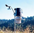
 The station is powered by a Davis Vantage Pro2
wireless weather station. The data is collected every 2.5 seconds and is updated on this web site every 5 seconds using Weather Display Software. The station comprises of a rain gauge, barometer, solar and ultraviolet sensors, thermo-hygro sensor, soil
temperature sensors, and leaf wetness sensor situated in
optimal positions for the highest accuracy possible. Wind speed and direction are provided by a R. M. Young Wind Monitor.
Radar data for storm watching is provided by Allison House and displayed by Gibson Ridge GRLevel3 software. Lightning detection is accomplished utilizing a Boltek StormTracker system and displayed with NexStorm software. Lightning data is immediately upchanneled to the StrikeStar system where it is combined with data from other stations and distributed to users such as Weather Underground.
Data is forwarded to the National Weather Service every 5 minutes via the Citizen Weather Observer Program (CWOP) which also conducts a Quality Control Program. Data is also sent to Weather Underground and Weather For You as Station Identifier KNEFRIEN3.
This location also serves as part of the National Weather Service Cooperative Observer Program (COOP) , the Plains Weather Network, and the Midwestern Weather Network.
Your comments and suggestions are always welcome. Contact us here .
About This Website
This site is a template design by Tom Chaplin at CarterLake.org. Special thanks go to Kevin Reed at TNET Weather. AJAX conditions display from Ken True at Saratoga-Weather.org. Template is originally based on Designs by Haran.
|
|||||||
Navigation
